The Xiate Trail: Hiking from the Ili Valley Over the Tianshan to the Tarim Edge
The Xiate (Xiate) Trail is one of Xinjiang‘s classic trekking routes: an old Silk Road and communications path that climbs from the green Ili side, tunnels through a pass in the Tianshan, and drops toward the arid south. It is tougher and quieter than the famous Duku Highway, and far more rewarding for hikers.
Key facts
The Xiate Trail runs in Zhaosu County (Ili) toward the former Xiate post, following the Xiate River up to a glacier-guarded pass. Historically it linked the northern and southern slopes of the Tianshan. Today the lower section is a managed scenic walk; the full crossing is a serious multi-day trek requiring permits, a guide, and good weather.
| Section | Style | Effort |
|---|---|---|
| Valley walk | Day hike | Easy–moderate |
| Glacier approach | Guided trek | Hard |
| Full crossing | Expedition | Very hard |
Arriving by road
Base yourself in Zhaosu (reachable from Yining), then drive to the Xiate scenic entrance. The valley day-walk is open to independent visitors; the high pass needs a licensed guide and usually a local horse or vehicle support. Ili Valley access is the natural jumping-off point.
What it costs to get in
The Xiate scenic area charges roughly 60–80 RMB entry plus a shuttle to the trailhead (about 40–60 RMB). A guided crossing costs substantially more — guide, pack animals, and permits can run into the low thousands for a small group.
Choosing months
June to September is the window; snow blocks the high pass outside it. July–August has the best trail conditions but the most mosquitoes near the river. September is colder but clearer.

A Day-Walk Itinerary
| Time | Plan |
|---|---|
| 08:30 | Shuttle from gate to trailhead |
| 09:30 | Walk the valley, riverside meadows |
| 12:00 | Picnic near the glacier view |
| 15:00 | Return shuttle, back to Zhaosu |
Rooms and what they cost
Sleep in Zhaosu town (basic hotels and guesthouses). For the full crossing, you camp en route with guide support — there is no lodging on the pass.
Food
Carry your own water and snacks; the trailhead has little. In Zhaosu, eat naan, samsa and lamb before you set out.
The mistake I made the first time
So: work out how far it is from where the vehicle drops you to the feature, then double it. I assumed two hours would be plenty. That is the number of hours the visit needs. It was, in the sense that I saw everything, and it was ruined in the sense that I saw everything at the same hour with the same crowd, and I spent the drive home meaning to come back and never did. What I would tell the version of me who planned it: put the slow hours in, not the fast ones.
The whole point of coming this far is to have the place to yourself for a while, and that only happens if you are willing to be there when it opens or when it is nearly shut. I did come back the following trip, at seven in the morning, and it was a different site. The other mistake is about distance on the map. The gate is not the site. There is a shuttle, a walk, sometimes another shuttle, and the stretch everybody underestimates is between the second gate and the thing you crossed the country to see.
I wrote the driving side up in our [[tangbula-gallery-xiate-trail-hiking-and-hot-springs|Tangbula Gallery & Xiate Trail Hiking and…]] as well.
Timing your visit to {P}
The second I gave it a morning and a late-afternoon return and saw two completely different places, because the light moved across the surface and the crowds thinned to nothing. My own rule now: if I have to choose between this and an extra evening in Ili, I keep the evening. Most first-timers plan two hours and then get stranded. Budget the full morning. The gates open early and the last entry tends to stop a couple of hours before closing, so the promise of coming back for sunset is not always possible.
Ninety minutes is enough to tick the box. That covers the walk in, the slow look at the main feature, the side trails almost nobody does, and getting back to the car before the light goes flat. Half a day is enough to understand it. A full day is what you want when the point of coming was The Xiate Trail Hiking itself rather than a stop on the way. The first time I rushed it and spent the whole visit looking up at the same rock from one spot.
Worth pairing with
Ask at the hotel desk the evening before what opened this week, because several of these places shift their hours with the season and the leaflet in the lobby is a year out of date. The stops most people miss are the small ones between the big names. The Xiate Trail Hiking sits naturally into a longer Ili day. With a car the combination that worked for us was the site in the morning, a long lunch somewhere with shade, and the other place in the late afternoon, so two half-days covered a full one.
Details that matter locally
- The high pass is glacier-fed and cold even in July — pack layers.
- Do not attempt the full crossing without a local guide and permit.
- Signal is unreliable; tell someone your plan.
- Check snow and weather in Zhaosu before committing to the upper trail.
FAQ
Can I do it without a guide? The valley day-walk, yes. The pass crossing, no — it requires a licensed guide and permits.
How hard is the full crossing? Multi-day, high altitude, glacier terrain — for fit, experienced trekkers only.
Is it open all year? No; the pass is snowbound outside roughly June–September.
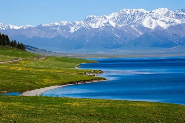
What’s the scenery like? River meadows, conifer forest, and a dramatic glacier at the top — very different from the south-side desert.