North Xinjiang Loop: Kanas, Hemu, and Sayram Lake in 7 Days

## Why the North Xinjiang Loop Captures Every Traveler’s Imagination
The North Xinjiang Loop—linking Kanas, Hemu Village, and Sayram Lake—isn’t just a road trip. It’s a seven-day immersion into some of Asia’s most dramatic alpine landscapes, where glacier-fed lakes shift color with the clouds, birch groves turn liquid gold in September, and Kazakh and Tuvan herders still move with the seasons.
This itinerary is designed for travelers who want the iconic postcard views *and* the quiet moments between them—the river mist at dawn, the smoke rising from a timber village, the sudden appearance of a snow-capped ridge on a clear morning.
Before diving into the day-by-day plan, it’s worth understanding why this particular triangle works so well. Each destination delivers a distinct personality: Kanas is the showcase lake with infrastructure and viewpoints; Hemu is the timber village where morning light and birch smoke create an almost mythical atmosphere; Sayram is the high-altitude alpine lake whose moods change by the hour. Together, they form a loop that avoids backtracking and maximizes landscape diversity.
For a deeper dive into each destination’s specific logistics—tickets, permits, best viewpoints—explore the dedicated guides on [Xinjiang Travel Tips](https://www.xinjiangtraveltips.com/), where you’ll find detailed breakdowns of Kanas’s Three Bays, Hemu’s sunrise platforms, and Sayram’s 90-kilometer ring road.
—
## Day 1: Urumqi to Burqin — The Gateway Town
Most travelers begin in Urumqi and make the drive north toward the Altai region. The first day is about positioning: the ~650 km journey from Urumqi to Burqin (布尔津) takes roughly 8–9 hours on the G216 corridor. It’s a long day of driving, but the landscape gradually transforms from semi-arid scrub into rolling pasture and distant mountain silhouettes.
Burqin itself is worth a stroll after dark. The riverside night market (not the indoor one) serves grilled river fish, laghman noodles, and lamb skewers. It’s also where you’ll see the distinctive wooden architecture that signals your arrival in northern Xinjiang’s timber country.
**Overnight:** Burqin town (hotels range from ¥150 functional to ¥600+ river-view). Book ahead for July–September.
**Practical note:** Fill up with fuel here. The next stretch into the scenic zones has fewer stations, and foreign credit cards aren’t widely accepted at remote pumps—carry sufficient cash (RMB) for fuel and tolls.
—
## Day 2: Burqin to Kanas Village — Entering the Biosphere
The 150 km drive from Burqin to the Kanas scenic zone entrance at Jiadenyu (贾登峪) takes about 3 hours on a paved mountain road. At Jiadenyu, you’ll park your vehicle (foreign-plated cars generally cannot drive inside the scenic zone—you’ll transfer to the mandatory park shuttle system) and board the shuttle bus for the 30 km ride into Kanas Village.
The shuttle ride itself is part of the experience. The road climbs through spruce forests, crosses wooden bridges over the Kanas River, and occasionally opens onto viewpoints where you can see the river’s glacial flour turning the water an opaque turquoise.
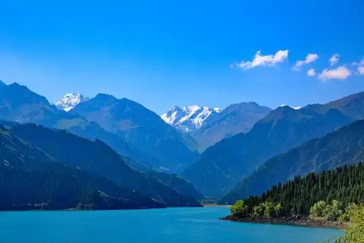
**Key activity—Guanyu Tai (观鱼台):** After settling into your accommodation in Kanas Village, head to the Guanyu Tai platform. You can either hike the 1,066-step stone staircase or take the shuttle + escalator (¥20–40 extra, depending on season). From the platform, you see the full S-curve of Kanas Lake with the surrounding peaks framing it. This is also where the legendary “lake monster” folklore originates.
**Overnight:** Kanas Village (wooden lodges, ¥200–800/night depending on season and plumbing quality). Staying inside the zone means you can catch sunrise at the bays without commuting in from Jiadenyu.
—
## Day 3: The Three Bays — Kanas’s Signature Landscape
Dedicate a full day to walking (or shuttle-hopping) between the Three Bays: Guanyu Tai (covered yesterday as the overlook), Moon Bay (月亮湾), Shenxian Bay (神仙湾), and Wolong Bay (卧龙湾). The classic approach is to take the morning shuttle to the uppermost bay and walk downstream along the riverside boardwalks.
**Moon Bay** is the most photographed: a crescent-shaped river curve with a small island in the center that supposedly resembles a footprint (or a dinosaur track, depending on who’s telling the story). The wooden stairs from the road down to river level take about 15 minutes each way.
**Shenxian Bay** is the mist destination. Visit at sunrise (yes, this means being on the boardwalk by 06:30 in summer, 07:00 in autumn) when the river channels are draped in layered fog. The effect is genuinely otherworldly—the “fairy bay” name makes sense once you see it.
**Wolong Bay** is broader and shallower, with a sandbar formation that resembles a reclining dragon (hence the name). It’s a good picnic spot and less crowded than Moon Bay.
By late afternoon, return to Kanas Village. If you’re visiting in September, the birch trees along the river flanks will be turning brilliant gold—this is widely considered the best month for photography.
For a comprehensive walkthrough of each bay’s best viewpoints, trail distances, and photo timing, check the [Kanas guide on Xinjiang Travel Tips](https://www.xinjiangtraveltips.com/), which includes a detailed map of shuttle stops and walking routes.
—
## Day 4: Kanas to Hemu — The Timber Village
After breakfast, take the shuttle from Kanas Village back toward the zone exit—but get off at the turnoff for Hemu (禾木). The Hemu scenic zone is separate from Kanas (you’ll need a separate entrance ticket: ~¥102 including shuttle) and sits in a narrower, more enclosed valley.
Hemu’s defining image is the cluster of pine-log cabins with smoke rising from tin chimneys, backed by snow peaks and a ribbon of birch forest. It’s undeniably photogenic, but the real magic is temporal: sunrise and sunset are when the light turns the log walls amber and the river catches the alpenglow.
**Hemu Viewing Deck:** A short hike (or horseback ride, ~¥80–150) takes you to the hillside platform above the village. Sunrise from this deck—with the village below, the river bending away, and the first light hitting the peaks—is one of China’s most famous landscape photographs. If you’ve seen a postcard of Xinjiang, this is likely what it depicted.
**Overnight:** Hemu Village (wooden guesthouses, ¥200–600/night). The accommodations are rustic: thin walls, shared bathrooms in budget options, and limited hot water during peak demand. It’s part of the experience—pack warm layers regardless of season.
—
## Day 5: Hemu to Beitun or Urho — Transition Day
After a sunrise shoot at the Hemu deck (do it again if yesterday was cloudy—the light changes completely), begin the journey southward out of the Altai Mountains. The drive from Hemu back to the nearest highway hub (Beitun or Urho) takes 5–7 hours depending on road conditions and how many photo stops you make.
This is a transition day, but don’t rush it. The mountain roads between Hemu and the G216 corridor pass through high pasture where you may see herds of cattle being moved by Kazakh riders, wooden bridges over turquoise streams, and occasional marmots sunning on rocks.
**Overnight option 1:** Beitun (a small city, practical but not scenic—good for restocking supplies).
**Overnight option 2:** Urho (closer to the next day’s destination, the World Devil City).
—
## Day 6: World Devil City — The Yadan Landscape
From Urho, the World Devil City (世界魔鬼城) is roughly 100 km away, about 1.5 hours by car. This Yadan landscape features wind-eroded rock formations that resemble castles and towers.
The site requires a mandatory shuttle bus (included in the ~¥62 ticket) that hops between numbered stops along a one-way loop. You cannot self-drive inside the geopark. Each stop has interpretive signage explaining the formation’s shape and the local folklore associated with it.
**Photography tip:** The late afternoon light (1.5 hours before sunset) is when the copper-red sandstone formations glow. The wind through the formations creates an eerie howling sound—hence the name “Devil City.”
**Overnight:** Karamay city (the nearest proper urban center, ~1 hour from the Devil City). Karamay has an airport with flights to Urumqi and other major cities, making it a logical place to recharge before the final leg.
—
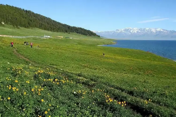
## Day 7: Sayram Lake — The Last Tear of the Atlantic
The final major destination on the loop is Sayram Lake (赛里姆湖), sitting at 2,073 meters in the Bortala/Ili corridor. At ~550 km from Karamay, this is a substantial drive (6–7 hours via the G30 expressway toward Yining). Plan to arrive at Sayram in the late afternoon so you can catch the sunset over the water.
Sayram is Xinjiang’s largest alpine lake, and its behavior is famously fickle—one hour it’s slate-gray, the next it’s electric cyan. The Mongol name “Sayram” means “blessing,” and the lake has a mythic quality: it’s said to be the “last tear of the Atlantic Ocean” because the westerly winds that carry the last moisture from the Atlantic drop it here before hitting the inland deserts.
**The Ring Road:** Unlike Kanas, where a single viewpoint dominates, Sayram is best experienced by driving its ~90 km lakeside loop. There are pull-offs every few kilometers: glacier viewpoints, nomadic yurt encampments, and photo platforms. The southeast inlet, where steppe grasses catch the evening light, is particularly spectacular.
**Overnight:** Either inside the scenic zone (yurt stays or the lakeside Muyun Camp, ¥300–800/night) or in nearby Yining city (1.5 hours away, more hotel options).
—
## When to Do This Loop — Seasonality Matters
The North Xinjiang Loop has a compressed season. Unlike southern Xinjiang, which is accessible year-round, the Altai region locks down in winter.
| Month | What You Get | Crowd Level |
|——-|————-|————-|
| June | Full green, wildflowers | Moderate |
| July–August | Warmest, all facilities open | High |
| September | **The sweet spot** — golden birch | Moderate–High |
| October 1–7 | Golden Week — extremely crowded | Very High |
| October 8–20 | Post-holiday calm | Low |
| November–April | Closed / inaccessible | N/A |
**The consensus among experienced travelers:** mid-September to early October, avoiding Golden Week (October 1–7). You get the golden birch, the clear air, and (if you time it right) the first light snow on the peaks while the lake is still unfrozen.
—
## Logistics That Actually Matter
**Transportation:** A private chartered 4×4 with driver is the most practical option for foreign travelers. The driver handles checkpoints (there are several in the Altai region), knows the seasonal road conditions, and can adjust timing for sunrise shoots. Expect to pay ¥1,200–2,000/day depending on vehicle and season. Self-driving is possible but requires navigating permit checks and occasional road closures.
**Accommodation:** Inside the scenic zones (Kanas Village, Hemu, Sayram Lakeside), accommodations are rustic. Don’t expect luxury. Outside the zones (Burqin, Beitun, Karamay, Yining), you’ll find standard Chinese business hotels and occasional upscale options.
**Altitude:** Kanas (~1,374 m), Hemu (~1,500 m), and Sayram (~2,073 m) are mild by Tibetan standards, but the combination of travel fatigue and cold nights can trigger mild symptoms. Stay hydrated and avoid alcohol on the first night at altitude.
**Connectivity:** Mobile signal is spotty inside the Kanas and Hemu valleys. Download offline maps and any reference materials before leaving Urumqi. The [Xinjiang Travel Tips](https://www.xinjiangtraveltips.com/) site is mobile-optimized and works on mobile data, but don’t rely on being able to look things up from inside the valleys.
**Cash:** Many guesthouses, horse-riding concessions, and yurt-stay families do not accept cards or WeChat Pay from foreign accounts. Carry ¥2,000–3,000 in small bills for the duration of the loop.
—
## Why This Loop Works as a Standalone Trip
Seven days is enough to experience three distinct alpine ecosystems. Kanas gives you dramatic lake views. Hemu gives you the timber-village atmosphere. Sayram gives you high-altitude solitude.
As a one-week introduction to Xinjiang’s northern landscapes, this loop is hard to beat.
Seven days is enough to experience three distinct alpine ecosystems without the trip feeling like a marathon.
—