Jiaohe Ruins: Walking the 2,000-Year-Old Desert City Near Turpan
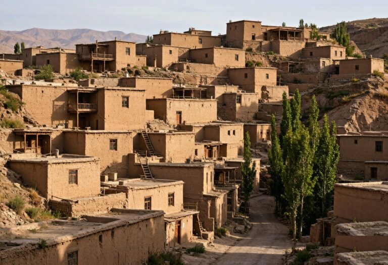
An hour south of Turpan, the ground simply ends. A narrow plateau — a tongue of clay between two rivers — juts into the desert, and on top of it sits Jiaohe, one of the best-preserved ancient cities in all of Central Asia. There are no walls, because the cliffs were the walls. There are no standing roofs, because the mud-brick has melted back toward earth over two millennia. But the streets, temples, and houses are still legible under your feet, and standing there at golden hour is the closest thing to walking through a vanished Silk Road kingdom I have experienced.
A Short History of Jiaohe
Jiaohe was the capital of the Jushi (Cheshi) kingdom from around the 2nd century BC, controlling the northern Silk Road route between Turpan and the west. Its name means “where two rivers meet,” referring to the Ya’er and Tuyoq gullies that protect it on three sides. It later fell under Han, then Gaochang, then Mongol control, and was finally abandoned after a massacre in the 14th century. Because it was built almost entirely of compressed earth on a wind-scoured plateau, it survived where stone cities elsewhere did not, and the dry climate did the rest of the preserving.
The Layout: A City Without Walls
Jiaohe’s genius was defensive geography. Settled on a 1,650 m-long, 300 m-wide mesa, it needed no outer wall — the vertical cliffs did the job. You enter from the south, where a narrow neck was the only land approach. From there the main avenue runs north, flanked by residential blocks cut down into the ground rather than built up, a technique that kept homes cool and hidden. To the west sit the Buddhist temples and a large monastery complex; to the east, the government and workshop district. It is a complete urban plan, just roofless, and you can trace the logic of the place within ten minutes of walking.
| District | What remains | Don’t miss |
|---|---|---|
| Southern gate & main street | The single land entrance and central axis | Walking the 1.6 km spine |
| Western temples | Stupas and monastery foundations | The great Buddhist complex |
| Eastern residences | Sunken houses and lanes | The underground workshops |
| Northern clifftop | Cemetery and city end | Panorama over both gullies |
How the Buildings Were Made
Most structures were “subtractive” — carved down into the plateau’s compressed loess rather than raised with bricks. That is why the streets feel like channels and the houses like pits. The few above-ground walls used rammed-earth techniques still used in Turpan oases today. It is an architecture of subtraction, uniquely adapted to a place with no stone and endless wind, and it is the reason the city reads so clearly from above: the negative spaces are the buildings.
Getting to Jiaohe
The ruins sit about 13 km west of Turpan city. The easiest route is a taxi or ride app from Turpan (roughly 30–40 minutes, 50–80 yuan one way), or a guided half-day tour that combines it with the nearby Karez wells. There is a visitor shuttle from the parking lot to the entrance, and the walk through the site itself takes 60–90 minutes at a relaxed pace. Pair it with our Turpan city guide for a full day out, and leave the late afternoon free for the light rather than the clock. If you are relying on public transport, the local Turpan bus to the Jiaohe stop runs a few times a day and costs only a few yuan, but the return can be sparse, so confirm the last departure before you head out to avoid an expensive taxi back.
What Makes Jiaohe Special Archaeologically
Most visitors come for the atmosphere, but archaeologists prize Jiaohe for its completeness. Because it was abandoned rather than destroyed by siege, the street grid, drainage channels, and even the outlines of workshops survive in a way that ruined stone cities rarely do. The western monastery alone contains dozens of stupa and cell foundations, evidence of a Buddhist population that thrived here a millennium before the region’s later Islamic character. Walking the central avenue, you can still see where the main road widens into a market square and where side lanes drop into sunken courtyards. It is a textbook of Central Asian urbanism, just waiting to be read by anyone who slows down.
Photography and Light
Jiaohe rewards patience with a camera. The compressed-earth walls pick up a warm rose tone in the first hour after sunrise and the last hour before sunset, while midday washes them flat and white. The clifftop northern end offers the widest panorama, with both gullies falling away beneath you. Drones are not permitted, but a standard zoom lens captures the texture of the rammed earth beautifully, and a small tripod lets you take long exposures of the empty streets at golden hour when the tour buses have gone.
Tickets, Hours, and the Best Time to Go
Jiaohe is open year-round, but it is a desert plateau with no shade, so timing matters. Spring (April–May) and autumn (September–October) are ideal — mild and photogenic. Summer is brutally hot; go at opening (around 9 am) or near closing for soft light. Winter is cold but nearly empty, and on a clear January morning you may have the entire city to yourself.
| Season | Conditions | Recommendation |
|---|---|---|
| Apr–May | Mild, occasional wind | Excellent |
| Jun–Aug | 40°C+, harsh midday sun | Go early or late |
| Sep–Oct | Cool, clear, golden light | Best |
| Nov–Mar | Cold, very quiet | Good for solitude |
Entry is around 70 yuan for adults, with discounts for students and children. Bring water, a hat, and sturdy shoes — the surfaces are uneven and the sun is relentless, and there is almost no shelter once you are out on the mesa.
Combine Jiaohe with Gaochang
Jiaohe’s sister city, Gaochang, lies 40 km east and follows the same earthen logic on a flat plain (it did need walls). Doing both in one trip shows two answers to the same problem — how to build a city of mud in a desert. The Silk Road history of the region makes far more sense once you have stood in both, and the contrast between cliff-edge Jiaohe and walled Gaochang is the clearest lesson in Silk Road urban design you will find anywhere in Xinjiang.
Things people ask me
How old are the Jiaohe ruins?
The settlement dates back more than 2,000 years, with the city reaching its height between the 1st century BC and the 8th century AD. It was abandoned in the 14th century.
Why are there no walls?
The city was built on a steep clay mesa between two rivers, so the natural cliffs served as defenses. Only the narrow southern neck needed guarding, and even that relied more on the terrain than on masonry.
How long should I spend there?
Plan 60–90 minutes inside the site plus travel time. A half-day with the Karez wells makes a satisfying Turpan excursion, and the two together explain how the oasis actually functioned.
Is Jiaohe worth visiting if I’ve seen Gaochang?
Yes. Jiaohe is the better-preserved and more atmospheric of the two, and the cliff-edge setting is unique. Seeing both reveals how distinct earthen-city design could be within the same civilization.
Can I visit independently without a tour?
Easily. Taxis and ride apps reach it from Turpan, and the site is self-explanatory with the on-site plaques. A guide adds depth but is not required, and the freedom to linger at golden hour is worth the small extra planning.
What should I bring?
Water, sun protection, and closed shoes. There is little shade and the walking surfaces are rough; the nearest facilities are at the entrance, so arrive prepared rather than hoping to buy on site.