Self-Drive in Xinjiang: What You Need to Know Before Renting a Car
Exploring Xinjiang by private car is, for many independent travelers, the single most rewarding way to experience this vast region. With an area of 1.66 million square kilometers — larger than Iran and nearly five times the size of Germany — Xinjiang’s distances between attractions are vast, and public transport simply cannot match the freedom of having your own steering wheel and the ability to stop wherever a viewpoint calls to you.
Last updated: July 15, 2026 · Written by Karl Huang, a Xinjiang travel specialist who has spent time across the region. Practical details are cross-checked against official tourism, transport, and border-regulation sources.
Why Choose Self-Drive Tourism in Xinjiang?

The case for a self-drive trip is straightforward. First, Xinjiang’s geography is defined by huge intermontane basins — the Junggar and Tarim — separated by massive mountain ranges: the Tianshan, Kunlun, and Altai. The straight-line distance from Urumqi to Kashgar is approximately 1,080 km — roughly the distance from Paris to Budapest.
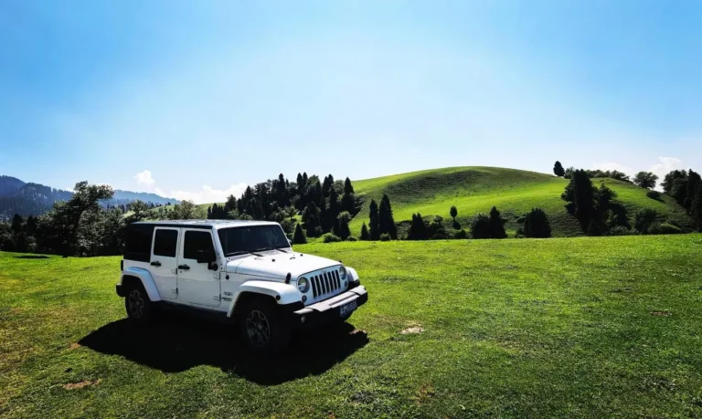
Second, some of Xinjiang’s most memorable experiences lie on unmarked side roads that no tour bus will ever visit: a Kyrgyz yurt encampment by Karakul Lake, a poplar-lined village in the Yili Valley, or a natural hot spring bubbling out of a roadside hillside. Self-drive gives you the agility to say “let’s stop here” without negotiating with a group itinerary.
Top Self-Drive Routes
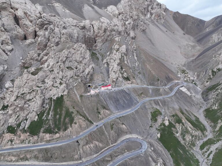
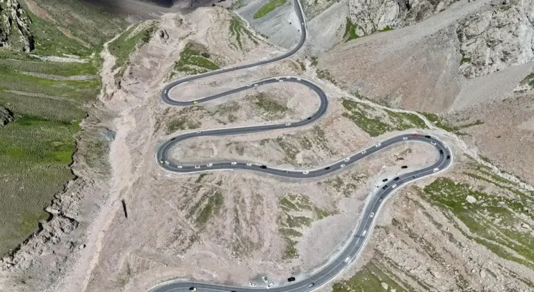
1. The Duku Highway (G217) — The Roof of the Sky Road
Stretching 561 km from Dushanzi in Karamay Prefecture to Kuqa in Aksu Prefecture, the Duku Highway is widely considered China’s single most scenic mountain road. It crosses the Tianshan range at an elevation of 3,393 m at the Bayinbrook Pass, linking the Junggar Basin in the north with the Tarim Basin in the south. The road took ten years to build (1974–1984) and cost the lives of 168 soldiers.
Highlights: Dushanzi Grand Canyon (starting point with glass-floor platforms), Nalati Grassland (the so-called “airport prairie” at 2,100–2,500 m), Bayinbrook Grassland (home to the famous Nine-Bend River sunset — arrive at least 90 minutes before sunset to claim a railing spot), and the Tianshan Grand Canyon near Kuqa (a red cliff slot canyon with a well-maintained 5 km walking trail). The road is typically open from June 1 to October 10, strictly weather permitting.
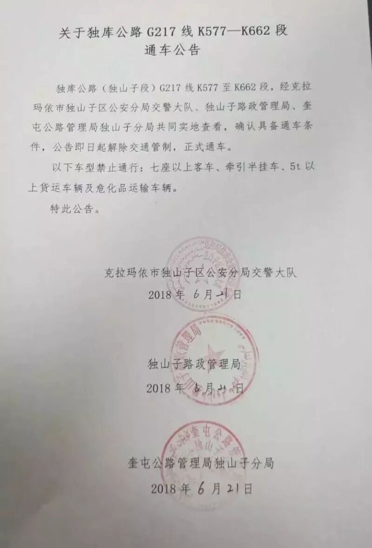
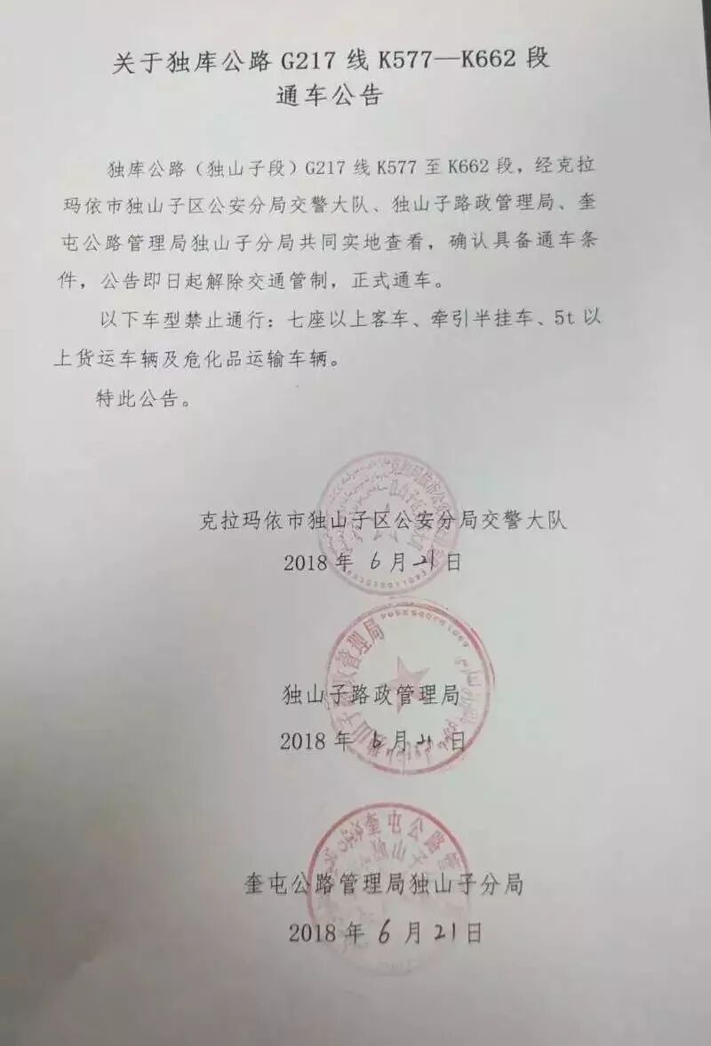
Practical note: Foreign travelers should always check the latest regulations on self-drive permits. Read our full Duku Highway guide here for the latest permit information.
2. The Karakoram Highway (G314) — To the Roof of the World
The Karakoram Highway (KKH), known in China as the G314, runs 1,300 km from Kashgar to Islamabad. The Chinese section — from Kashgar southwest to the Khunjerab Pass at 4,733 m — is one of the highest paved roads on Earth. For self-drive travelers based in Xinjiang, the realistic day-trip or overnight target is Karakul Lake at 3,600 m and Tashkurgan town at 3,090 m.
Highlights: Baisha (White Sand) Lake (entrance approximately ¥40, well worth a 30-minute photo stop on the north shore), Subash Pass (the viewpoint where the lake first reveals itself as you crest the ridge — this is the money shot that appears in every Xinjiang coffee-table book), Karakul Lake’s stunning glacial reflection of Muztagh Ata at 7,546 m (locally known as the “Father of Glaciers”), and Tashkurgan’s Stone City (a 2,000-year-old fort ruin complex built on a massive earthen platform with 360-degree views). You will need a border-zone PSB permit (边防证), which must be arranged in Kashgar before your departure.
Altitude warning: The road climbs from 1,280 m in central Kashgar to 3,600 m at Karakul Lake in under four hours of actual driving time. Acclimatize in Kashgar for at least one full night before driving up. Descend immediately if vomiting or confusion sets in.
3. The Taklamakan Desert Highway (G216) — Crossing the Sea of Death
The Taklamakan is the world’s second-largest shifting-sand desert, covering approximately 337,000 km². Crossing it on the designated Desert Highway is a genuine once-in-a-lifetime driving experience: 450 km of arrow-straight asphalt bounded only by dune ridges to the left and right, and weathered telephone poles marching like solitary soldiers across the void to the horizon.
Route planning: The classic north–south traverse runs from Luntai in the north to Minfeng in the south. A 4×4 SUV is mandatory if you plan any dune detours; the main highway is fully paved and reasonably well-maintained, but a tire blowout in the middle of the desert, with ambient temperatures potentially exceeding 45°C, is not the place to discover that your spare tire is also punctured or missing.
Fuel and supplies: Fill up completely at Luntai before departure and again at Tazhong (塔中, approximately km 220 along the highway), which is a surreal oilfield outpost in the middle of the dunes that has basic noodle shops, a dormitory for workers, and little else. Carry at least 3L of drinking water per person — the impossibly dry desert air hides sweat loss because perspiration evaporates almost instantly.
4. The Yili River Valley Ring Road — Grassland and Blossom
In the far western corner of Xinjiang, the Yili River watershed (Ili Prefecture) receives sufficient westerly moisture from the prevailing jet stream that it can grow blanket wildflower meadows instead of the desert scrub that dominates the rest of the region. A spectacular 400–500 km ring road from Yining (also called Ghulja) takes in an extraordinary variety of landscapes within a single day’s drive: Sayram Lake at 2,073 m (Xinjiang’s largest alpine lake, famous for dramatic color shifts from jade-green to electric cyan depending on cloud cover and wind direction), Guozi Gorge (spectacular valley viaducts where the highway seems to float above the treetops), lavender fields near Huocheng (mid-June to early July — the scent of lavender alone, drifting through your open car windows, is worth the detour), Nalati Grassland and the Sky Prairie (accessible via a separate park shuttle system that departs from the main gate), and finally Tekes Bagua City (the circular I Ching eight-trigram-layout town, which is the only legally planned circular city layout in all of China).
This ring road route is at its absolute best when driven in June during lavender season or in September when the grasslands turn golden, the air is crisp, and the domestic tour buses have largely departed for the season.
Essential Practical Planning Tips for Self-Drive Tourism
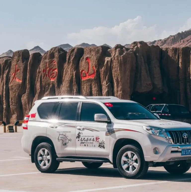
Car Rental — What Foreign Travelers Need to Know
Major international and domestic rental agencies including Hertz, Avis, and the leading Chinese platforms such as ZIPPO Car Rental (至尊租车) and Shenzhou Car Rental (神州租车) all maintain service counters at Urumqi Diwopu International Airport and, to a lesser extent, at Kashgar Airport. For foreign passport holders, several critical points matter:
- Driver’s license requirement: A valid Chinese driving license is strictly required for any form of self-drive in mainland China. International Driving Permits (IDP) issued under the 1949 or 1968 conventions are not recognized in mainland China.
- Insurance coverage: Ensure that your rental agreement includes comprehensive insurance covering collisions, theft, and third-party liability. Roadside assistance is available along major highways but may take 3–6 hours to reach remote desert or mountain stretches.
Documents and Permits — Do Not Skip These
Besides your valid driving license and passport, two specific documents merit your attention well before you arrive in Xinjiang:
- Border-zone PSB permit (边防证): This is absolutely required for visiting Karakul Lake, Tashkurgan, Baihaba Village, and several other border-zone destinations near the Kazakhstan, Kyrgyzstan, Tajikistan, Afghanistan, and Pakistan boundaries. Apply at the Kashgar Public Security Bureau (PSB) with your passport; the process typically takes 1–2 hours and is free or nominally priced at ¥10–20 for the document. Crucially, you must list ALL destinations you plan to visit in the border zone on the application form — if you omit Baihaba and later decide to go there, you will be turned back at the checkpoint and must return to Kashgar to amend the permit.
- Self-drive route approval notifications: Certain scenic areas including the Kanas buffer zone and the Taklamakan Desert crossing may require you to file a notification of your itinerary with local police or tourism bureaus. Your rental agency or hotel front desk can advise on current rules, which change periodically depending on security conditions.
Best Seasons for a Self-Drive Trip
Xinjiang’s climate is nothing if not extreme. The self-drive season breaks down roughly as follows:
- May–June: Spring thaw gradually works its way up the mountain slopes; grasslands turn brilliant green; wild apricot blossoms in the Yili Valley (early April is actually the peak for blossoms, but May is far more pleasant for driving). Daytime temperatures range comfortably from 15–25°C. This is widely considered the best overall driving season before the summer heat arrives and domestic crowds peak.
- July–August: The warmest months of the year; Turpan in the depression can exceed 45°C in the shade; the Duku Highway is fully open end-to-end; domestic tourist crowds reach their annual peak during the July–August school summer holiday period. Air conditioning in the vehicle is not optional at this time of year — it is survival equipment. Book all accommodation well in advance.
- September–early October: Widely considered by experienced Xinjiang drivers as the single best window of the entire year. Grasses in Bayinbrook and Nalati turn a spectacular golden color; Kanas’s white birch forests ignite in yellow; the air is crisp and clean; and crowds thin dramatically after the mid-October National Day holiday (October 1–7). September is the genuine sweet spot.
- November–April: Many high-mountain passes (including the Duku Highway) are completely snow-closed. Self-drive is possible only in the basin lowlands (the Urumqi–Turpan corridor).
Fuel and Accommodation Planning
Fuel: Gas stations are frequent along major highways (G30 Lianyungang–Khorgas, G314, G217). In remote desert or mountain stretches, fill up whenever the tank drops below half. All stations require ID registration for foreign passport holders — budget an extra 5–10 minutes per stop for the paperwork and security check. Diesel is available everywhere; EV charging stations are expanding but still sparse in remote areas.
Accommodation: Booking ahead is essential for July–August and the National Day week (October 1–7). Options range from luxury (Shangri-La Urumqi, Kashgar Radisson) to authentic yurt stays (¥80–300/night on the grassland). In peak season, mid-range hotels in popular destinations (Kashgar, Yining, Urumqi) can sell out days in advance — book at least a week ahead.
Safety Considerations Every Self-Drive Traveler Must Respect
Altitude sickness is a genuine medical risk, not a travel inconvenience: Much of Xinjiang’s most scenic driving is above 2,000 m elevation. Karakul Lake sits at 3,600 m and the Duku Pass reaches 3,393 m — both can trigger altitude sickness even in fit, healthy, acclimatized travelers. Ascend gradually (spend at least one night at an intermediate elevation), stay rigorously hydrated with at least 3L of water per day, and descend immediately if vomiting or confusion sets in. Acetazolamide (丹木酮) can help with prevention but requires a doctor’s prescription in China — consult your physician before departure.
Weather changes with shocking speed in the mountains: Snow can fall on the Duku Highway even in early June or late September when you least expect it. Always carry a warm layer (a down jacket that compresses into a stuff sack is ideal) and check the highway status hotline before setting out each morning. Download a reliable weather app that works offline, as mobile data can be intermittent in the mountains.
Road conditions are generally good but not perfect: The major highways (G30, G314, G217) are fully paved and well-maintained. However, sections under active repair or expansion (notably ongoing expansion work on G314 and G217 as of the 2025–2026 season) may have unpaved gravel detours of 10–30 km. A spare tire in good condition, a functional jack, and a basic tool kit are absolutely essential.
Conclusion
Self-drive tourism in Xinjiang is not merely a way to get from A to B — it is the journey itself. Plan carefully, respect the altitude and weather, and give yourself more time than you think you need. The reward is a road trip that will redefine your sense of scale.
For more destination guides, visit our Xinjiang Travel Tips homepage.
How many days do I need?
Plan 10-14 days for a comprehensive trip covering both north and south Xinjiang. Minimum 7 days for one region.
Is it safe for solo travel?
Xinjiang is very safe for independent travelers. Strong security presence, good infrastructure, welcoming locals.
What’s the best transport option?
Hire a driver (300-500 RMB/day) for flexibility, or use trains/buses for budget travel between major cities.