Flaming Mountains Practical Guide: Beat the Heat, What to See, and Tickets
The Flaming Mountains (火焰山) are the red sandstone range east of Turpan made famous by Journey to the West — and they live up to the name: this is routinely one of the hottest places in China, often above 40°C in summer. This is the practical “how to visit without melting” version; for shooting the red rock, see the Flaming Mountains photography guide.
Where it is
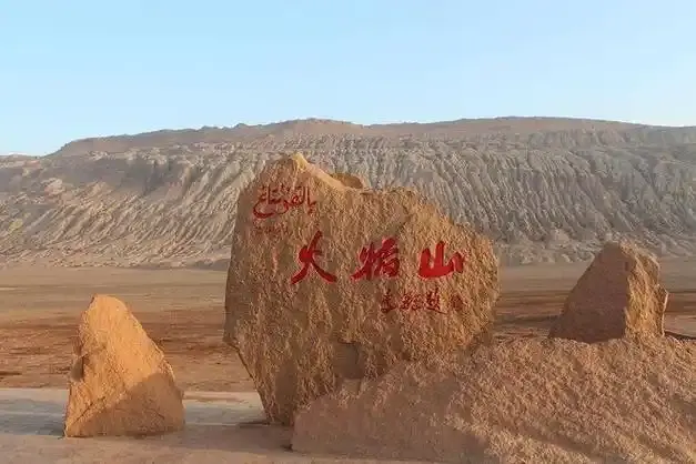
The range runs between Turpan city and the Grape Valley, on the way to the Bezeklik caves. The scenic area has the famous giant thermometer and a Journey to the West statue at the main pull-off.
When to go (the whole point)
- Avoid midday in summer — it is genuinely dangerous to linger in the open heat.
- Sunrise / sunset: the rock glows and the temperature drops to merely hot. Best windows.
- Spring and autumn: the comfortable seasons to actually walk the area.
What to see here
- The red cliffs: the main draw — layered, eroded sandstone in shades of rust and orange.
- The scenic-area stops: the thermometer, the statue, the viewpoint platform. Touristy but quick.
- Combine with shade: pair the Flaming Mountains with the cool Grape Valley next door and the earthen Jiaohe ruins for a full day.
Practical notes
- Tickets: the scenic area is a paid stop; budget it with your Turpan day.
- How long: 1–2 hours is plenty if you arrive at the right time of day.
- Water and cover: non-negotiable; there is no shade on the rock itself.
Just how hot
The Flaming Mountains aren’t named for drama — this stretch routinely tops 40°C in summer and has recorded some of the highest temperatures in China. The famous giant thermometer at the scenic area is a photo op precisely because the number is genuinely startling in July and August. That heat is the whole reason to plan your visit around the edges of the day rather than its middle.
A Turpan day plan
The Flaming Mountains sit between Turpan city and the Grape Valley, on the way to the Bezeklik caves and the Jiaohe ruins — so they’re rarely a stop on their own. A workable day: Grape Valley (cool, green, shaded) in the late morning, the Flaming Mountains at sunset when the rock glows instead of glares, then the earthen Jiaohe ruins for golden-hour silhouettes. That order keeps you out of the worst heat and stacks the good light back-to-back.
The money, line by line
Parking, a printed map, and a guide are the other three places the number moves. On top of it comes a shuttle or sightseeing bus inside the site, and if you want a far viewpoint rather than the main one that is another leg. Two of us covered the whole thing for well under what a single hotel night in Xinjiang costs, but only because we shared the car and shared the entry between us. On your own the same afternoon comes out at maybe half again as much. Prices at the gate are reasonable by European standards, which is exactly why they are easy to underestimate.
The admission is cheap, the internal transport is what adds up, and a family of four in one car turns a small ticket into a real line in the budget. Ask once at the ticket office what the full circuit costs before you commit. Staff there are used to it, and the answer takes ten seconds. The headline entrance ticket is only the first line. If the timing is the question, our [[xinjiang-flaming-mountains-travel-guide|Flaming Mountains Photography: Golden Hour…]] goes through it properly.
A few minutes of background change the visit
The place only makes sense once you know its shape. Flaming Mountains Xinjiang was cut rather than built, which is why the walls are solid and the streets are the empty space between them, and why centuries of dust ended up acting as a roof. Read that the morning before rather than at the entrance, where the boards stand too far from the object to help. Locals in Xinjiang will give you the short version in about a minute if you ask, and it is usually better than the panel at the gate. Knowing what you are standing on turns a pleasant walk into something you actually remember. The history here is layered in a way the official signage compresses into names and dates. Where most people get the logistics wrong is covered in our [[tianshan-mountains-xinjiang-travel-guide|Which Tianshan Section to Visit: Tianchi vs…]].
What to bring
- Water, constantly — there is no shade on the rock itself; dehydration is the real risk, not the view.
- Cover: a hat and a light long-sleeve beat the sun better than sunscreen alone.
- Timing buffer: 1–2 hours at the scenic area is plenty if you arrive at the right hour; don’t linger at midday.
Buy the scenic-area ticket as part of your Turpan day rather than separately, and the heat becomes a feature — red sandstone at sunset is worth the planning.
Tickets and the photo spot
The scenic area is a paid stop with a giant thermometer and a Journey to the West statue at the main pull-off; budget it with your Turpan day rather than as a standalone errand. For the iconic shot, frame the red cliffs with the thermometer or a yurt in the foreground at sunset, when the rock reads as sculpture instead of glare and the temperature finally drops to merely hot.